Introduction
The MAPS Project (Methods and processes for the Analysis of Pluristratified Sites) aims to test the study of long-lasting urban centres with a holistic approach, providing in-depth knowledge of urban landscapes and their development over the centuries 1 .Pompeii and Ravenna were chosen as two case-studies, since they offer quintessential examples of ancient cities with two apparently substantial different evolutions: in the first case, a pre-Roman and Roman centre suffered a strong break in ancient time, corresponding to the volcanic eruption of 79 BC when it was buried, and its life has restarted from the 18th century but in a considerably distinct manner, as an extensive archaeological site; in the second case, the ancient settlement, whose establishment dates back to pre-Roman era, has developed through over twenty-two centuries and has maintained itself in the present-day city of Ravenna. However, although a huge amount of data is available for the sites under examination, research has focused on best documented phases.
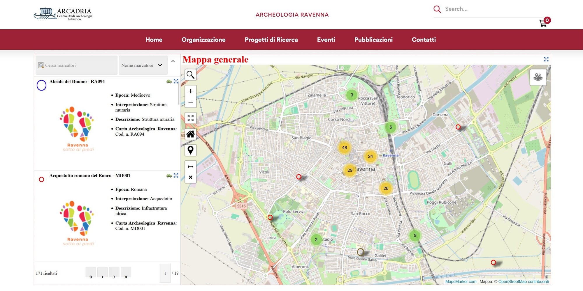
The case of Ravenna is emblematic: on the one hand, from the wider public perspective the city is popular mainly for its Late Antique and medieval monuments; on the other hand, in the last decades relevant studies have dealt with the extremely complex urban history of Ravenna starting from archaeological findings in a diachronic perspective and considering the relationship with geomorphology of the area (Susini 1990, Manzelli 2000, Cirelli 2010; Boschi 2013, David 2013a). In this framework, the widespread use of GIS has enhanced the knowledge and enabled data to be brought together within databases that can be constantly updated and easily accessible. A first step in this direction was taken by the Tolomeo LAB of the University of Bologna together with the Centro Studi per l’Archeologia dell’Adriatico, with the project named Ravenna sotto i piedi (“Ravenna under your feet”) 2 . Through a webGIS interface, a database gathering bibliographical data regarding archaeology in the inner city was made available online, allowing scholars but also citizens and tourists to learn about the remains of Ravenna that cannot be seen but exist right below where they walk (Figure. 1). In order to bring together the forces of those organisations involved in research and management of archaeological heritage, an agreement was signed between the University of Bologna (Department of History and Cultures, Department of Cultural Heritage), the Superintendence of Ravenna (SABAP RA-FC-RN), and the Municipality of Ravenna. This allowed the project to start data collection and to put them in a Territorial Data Infrastructure (TDI) platform, shared with the other partner of the project, which combines data managing and data sharing technologies with advanced flows of data integration, ensuring that every information is coherent and blended, to support in-depth spatial analysis; the architecture of the TDI was designed according to the specific needs of the project and the type of data-entry, and considering previous positive experience of urban archaeological maps (Carandini, Carafa 2017; Iacopini 2025). Thanks to the agreement, the fieldwork has begun on three side: the collection of legacy data, the study of two core-samples, and the study of unpublished archaeological material of a selected area.Fieldwork and methods
After thorough bibliographic research, the acquisition of legacy data mainly involved documents owned by public institutions. A first step was to obtain the archaeological map of the Municipality of Ravenna (CPA), part of the Urban Planning Regulation (RUE). Then, an important part of data collection involved archival data of the local Superintendence for archaeology. Whereas currently all documents recording archaeological works are stored in the archive of the Superintendence of Ravenna (SABAP RA-FC-RN), those prior to the reforms concerning the organisation of the public departments can be found in the historical archives at the offices of the SABAP BO in Bologna. Therefore, targeted archival research was needed. All the data collected, mainly consisting of old unpublished archaeological reports and plans, were digitised, and flowed into the TDI, making them available through the custom-made GIS interface.
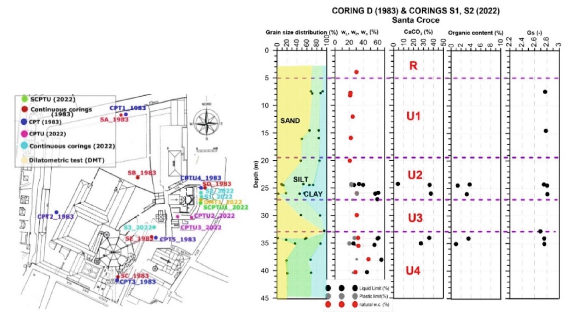
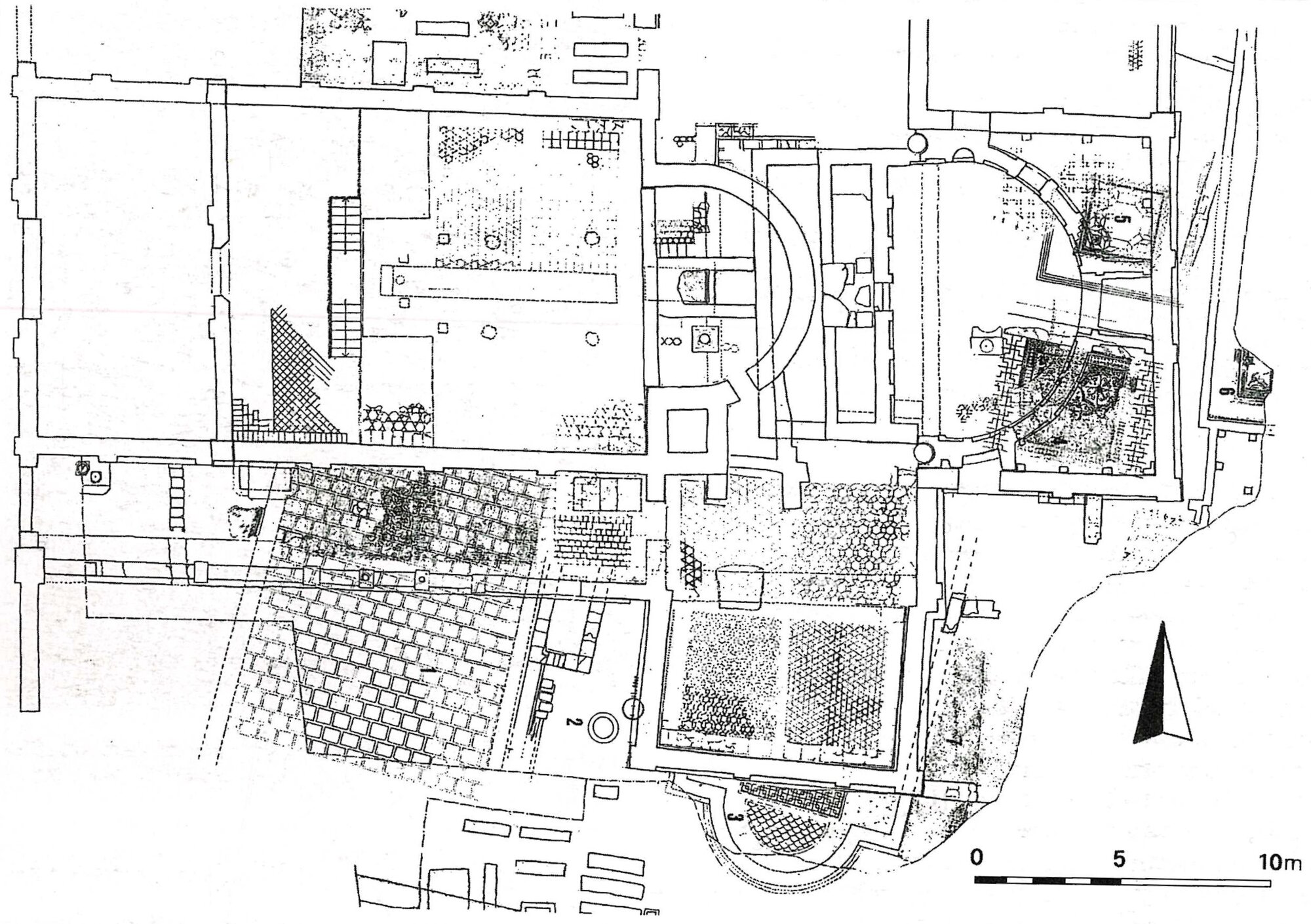
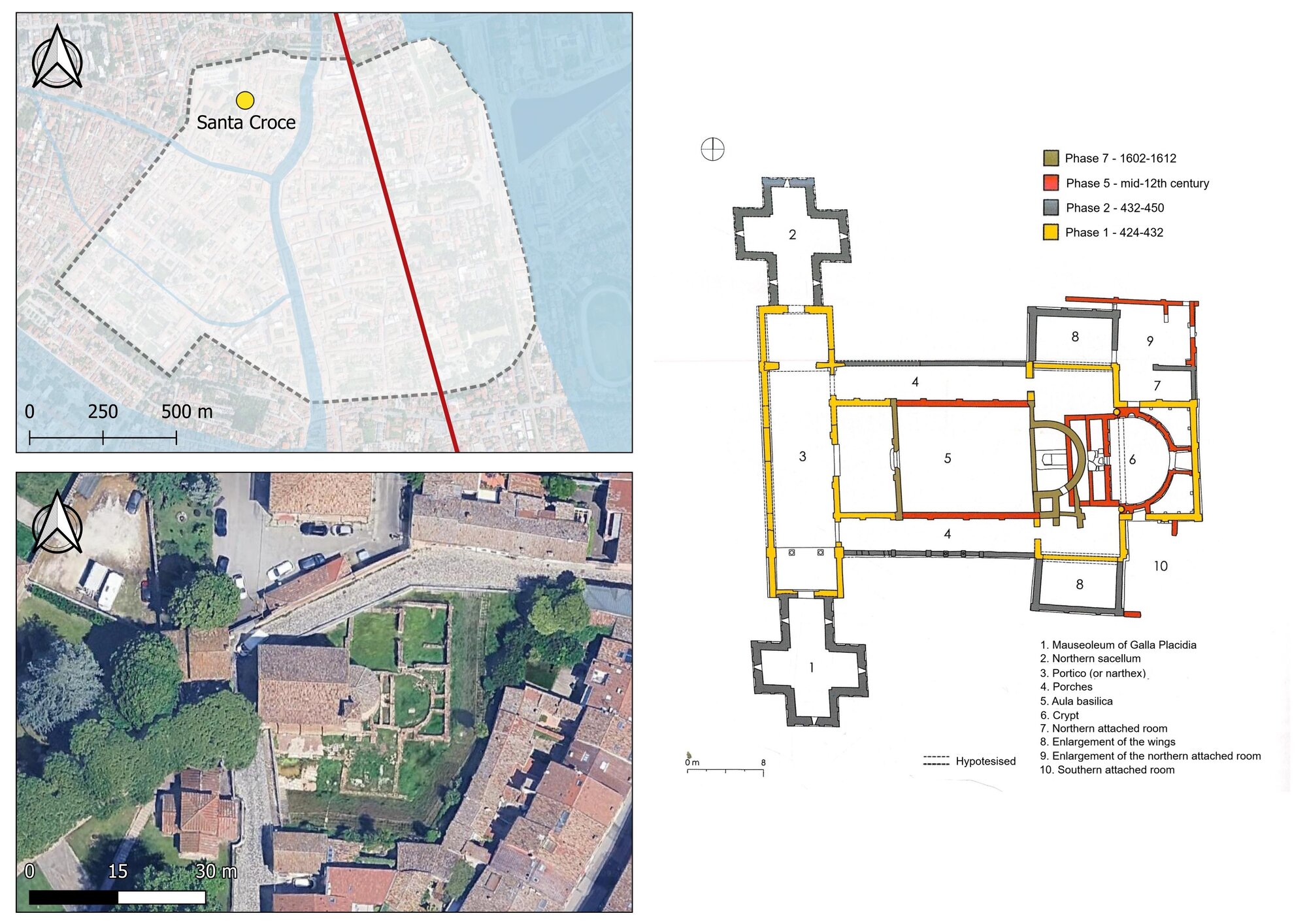
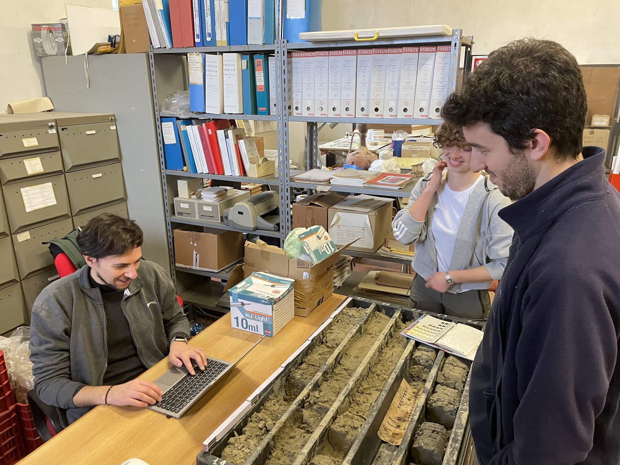
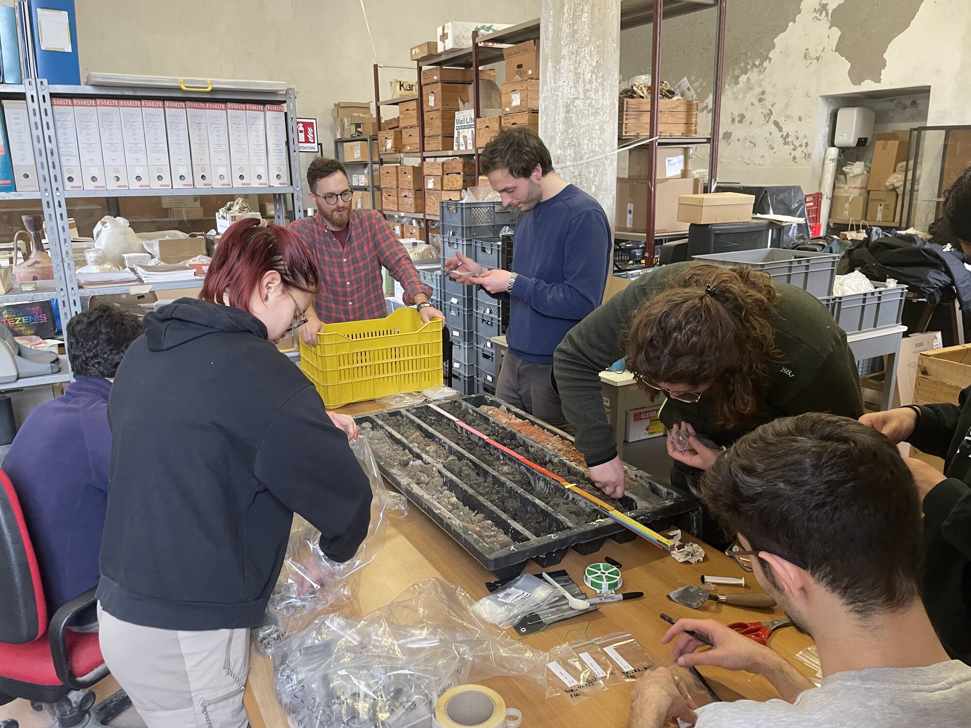
Simultaneously, the other main issue about Ravenna, on which the project is focused, is paleoenvironmental research. Bearing in mind that in long-term urban settlements extensive excavation are out of the ordinary, also when they occurred in the framework of rescue archaeology, it is difficult to obtain samples for this type of analysis. Nevertheless, other activities often carried out for non-archaeological purpose can be helpful. Among these, coring is the most common, also due to its relatively low-cost, the short time needed for fieldwork, and because it does not require large open areas. Thanks to the cooperation with the Superintendence of Ravenna, two core samples were recovered in its storehouse. They were realised in 2022, when some geotechnical investigations were conducted (Figure. 2) in the archaeological area of Santa Croce by the University of Bologna in the framework of the SHELTER Project (Bitelli, et al . 2021). Those activities aimed at studying and monitoring the existing drainage system and identifying the local hydrogeological and geotechnical characteristic (Marchi, Bertolini, and Gottardi 2023; Marchi, Bertolini, and Gottardi 2024). Since the archaeological remains are exposed but lie several meters below ground level, they are threatened by flooding related to subsidence; a phenomenon that affects the entire area around Ravenna (Ugolini, et al . 2020; Bertolini, et al . 2023) 3. The archaeological area of Santa Croce is located in a crucial sector of the ancient settlement. In the Roman period it overlooked the northern bank of the Flumisellum , an ancient small watercourse flowing east-west, which likely marked the border of the city to the northern side and corresponds to the path of present-day Corso Cavour (Morsiani, Montevecchi 2025). Further north, beyond the Flumisellum , a suburban area expanded, at least from the Augustan period, when a stone bridge – the pons Augusti , under the modern via Salara – and some residential facilities were built (Figure. 3). These include a large domus with black and white and polychrome mosaic floors, whose remains were excavated during the 1970s and 1980s, and can still been seen today from via Galla Placidia, despite their poor state of preservation (Sericola, Agostinelli, and Ugolini 2020). After some restoration during the Imperial age, the complex was abandoned in the 3rd century AD, probably following a fire. The area was re-settled in the 5th century: at this time, the area north to the Flumisellum was probably comprised in new Late Antique city enceinte, much larger than the Republican one, built after the capital of the western part of the Empire was moved from Milan to Ravenna. Between 424 and 432 a new magnificent church, dedicated to the Holy Cross, arose by the will of Galla Placidia right over the collapsed and levelled Roman domus and it was soon enlarged between 432 and 450 (David 2013b, 13). In this period, the church had cruciform plan with three naves and a porch on the front side, with two small buildings – chapels or sacella for funerary purposes – at its opposite extremities (Figure. 4). Originally, the southern building was likely dedicated to Saint Laurence, while from the 9th century it was entitled to Saints Nazarius and Celsus; the northern one was hypothetically attributed to the monasterium of Saint Zacharia known by the sources (Cirelli 2008, 235; David 2013b, 15–18). At the present, only the southern one survives: the so-called Mausoleum of Galla Placidia (Cirelli 2008, 254). In the following centuries, the church was part of the north-western quarter of the city, where several sacred buildings were erected. The church underwent some other modifications in the 14th century, but at the beginning of the 17th century the earliest structure was almost completely dismantled: the remains of the narthex were demolished, separating the so-called mausoleum from the main fabric, and the church was reconstructed in smaller dimensions, shortening the length of the church nave towards the façade, which was moved back. Probably in the same period, a bell tower was added (Novara 2022, 15–18). The first core sample (S2) was carried out a few metres east of the apse of the Placidian church, on the slope of the depression created after the archaeological excavation, and provided a continuous sequence 35 m deep; the second core sample (S3) was taken some metres south-west of the so-called mausoleum, in the garden of the basilica of San Vitale, providing a sequence 13 m deep. For each of the two core samples, systematic sampling was conducted at the laboratory of the Superintendence in Ravenna, in the framework of a workshop on urban archaeology and geoarchaeology for the students of the First and Second Cycle Degree in History and Archaeology 4 (Figure. 5 Figure. 6). The activities resulted in a large number of samples for geoarchaeological, geochemical, paleo-environmental, and targeted archaeological analysis, including carbon-14 dating, which will be carried out by specialised laboratories in the next months. In conjunction with the work on core samples from the area of Santa Croce, the re-analysis of the excavation of viale Galilei has been undertaken. In the spring and summer of 1995, a rescue archaeological activity was carried out during the construction of a private building on the southern edge of the modern city, between the channels Scolo Lama and Fiumi Uniti. This part of the periphery of Ravenna is little-known and the hypothesis locating the Augustan port in this area has never been clearly confirmed by archaeological evidence, despite it is very likely that the Roman harbour was located south of the ancient settlement (Cirelli 2008, 27). During the mid-1990s excavation in viale Galilei, archaeologist found a section of an ancient road, which was rebuilt several times until the Late Antique period, the remains of at least two imposing brick structures, and a single infant burial covered with tiles (Unpublished report in the SABAP BO archive). The preliminary survey of the material evidence showed that the area was settled from the Republican period to Late Antiquity (5th-6th century AD). However, a specific study of the archaeological findings is needed, together with the re-examination of the unpublished documentation 5 . This will provide new data about the development of the ancient city of Ravenna and possible relationship with the road network as well as the Augustan harbour.Conclusion
The study of cities characterised by the persistence of settlement to the present day is challenging for urban archaeology, especially for the earlies phases. In the case of Ravenna, in addition to the difficulties connected to the presence of the modern urban fabric, other issues have emerged. First, the ancient settlement was deeply remodelled in Late Antiquity, when it became capital of the Western Empire, and in Middle Ages. Furthermore, radical environmental changes have transformed the landscape of Ravenna over time. Therefore, the MAPS Project offers an integrated approach to face challenges related to pluristratified urban landscape. A digital sharing platform with a GIS interface was created to manage different types of data; among them, a substantial part was made of legacy data collected from bibliography and archives. At the same time, analysis on core-samples from the area of the church of Santa Croce has given the opportunity to examine in depth the development of the urban landscape over a long-time span, comprehending earlier phases of settlement, and to focus on paleo-environment – it is worth noting that samples came from coring for non-archaeological purposes. On the other hand, a more traditional approach will provide information about an unpublished excavation in the southern sector of the city, through the study of archaeological materials from the site of viale Galilei. All these activities have been possible thanks to the willingness and the collaboration between the University, the public authorities for the protection of cultural heritage, and the local agencies. In this way, data sharing not only provides an updated picture of the wide archaeological context of Ravenna but also gives the possibility, thanks to the TDI platform, to make it known to a wider audience at different levels.References
- Bertolini, I., G. Gottardi, M. Marchi, and A. Ugolini, 2023. “Cultural heritage and subsidence: the emblematic case study of Santa Croce in Ravenna (Italy)”. In TISOLS: Tenth International Symposium on Land Subsidence - living with subsidence. Proceedings of the International Association of Hydrological Sciences (PIAHS) Volume 382, 2020, edited by P.A. Fokker and G. Erkens, 31–35. Red Hook: IAHS- Curran Associates.
- Bitelli, G., E. Barbieri, V.A. Girelli, A. Lambertini, E. Mandanici, E. Melandri, D.S. Roggio, A. Santangelo, M.A. Tini, S. Tondelli, and A. Ugolini, 2021. “The complex of Santa Croce in Ravenna as a case study: integration of 3D techniques for surveying and monitoring of a historical site”. In Proceedings of the joint international event 9th ARQUEOLÓGICA 2.0 & 3rd GEORES, edited by J.L. Lerma and M. Cabrelles, 408–13. València: Editorial Universitat Politècnica de València.
- Boschi, F. (ed.). 2013. Ravenna e l’Adriatico dalle origini all’età romana. Bologna: Ante Quem.
- Carandini, A., P. Carafa (eds). 2017. The Atlas of Ancient Rome. Biography and Portraits of the City. Princeton: Princeton University Press.
- Cirelli, E. 2008. Ravenna: archeologia di una città. Borgo S. Lorenzo: All’Insegna del Giglio.
- Cirelli, E. 2010. “Ravenna – Rise of a Late Antique Capital”. In Debating Urbanism. Within and Beyond the Walls. A.D. 300-700. Proceedings of a conference held at the University of Leicester, 15th November 2008, edited by D. Sami and G. Speed, 239–63. Leicester: University of Leicester.
- Cirelli, E. 2013. “La topografia della «Gaita di Santa Maria Maggiore» dall’Antichità al Medioevo”. In La basilica di Santa Croce. Nuovi contributi per Ravenna tardoantica, edited by M. David, 67–92. Ravenna: Edizioni del Girasole.
- David, M. 2013a. Ravenna eterna. Dagli Etruschi ai Veneziani. Milano: Jaca Book.
- David, M. 2013b. “Evergetismo imperiale e rinnovamento urbanistico a Ravenna in età teodosiana”. In La basilica di Santa Croce. Nuovi contributi per Ravenna tardoantica, edited by M. David, 11–40. Ravenna: Edizioni del Girasole.
- Iacopini, E. 2025. “The Archaeological Map of Ancona: new IT tools”. GROMA. Documenting Archaeology 10 (2025): 144-152.
- Leoni, C., and G. Montevecchi. 2018. “Lo scavo di piazza Andrea Costa nel contesto archeologico del settore urbano”. In Il Genio delle Acque. Scavi nelle piazze di Ravenna, edited by C. Guarneri, G. Montevecchi, 255–81. Ravenna: Longo.
- Maioli, M.G. 2018. “Antiche acque di Ravenna”. In Il Genio delle Acque. Scavi nelle piazze di Ravenna, edited by C. Guarneri, G. Montevecchi, 331–42. Ravenna: Longo.
- Manzelli, V. 2000. Ravenna. Roma: L’Erma di Bretschneider.
- Marchi, M., I. Bertolini, and G. Gottardi. 2023. “Geotechnical Investigations and Monitoring of the Archaeological Site of Santa Croce”. In Geotechnical Engineering in the Digital and Technological Innovation Era, edited by A. Ferrari, G. Gottardi, M. Ziccarelli, M. Rosone, and G. Gottardi, 536–43. Cham: Springer. https://doi.org/10.1007/978-3-031-34761-0_65.
- Marchi, M., I. Bertolini, and G. Gottardi. 2024. “Endangered historic sites: The case study of Santa Croce in Ravenna (Italy)”. In Geotechnical Engineering Challenges to Meet Current and Emerging Needs of Society. Proceedings of the XVIII ECSMGE 2024, edited by N. Guerra, M. Matos Fernandes, C. Ferreira, A. Gomes Correia, A. Pinto and P. Sêco Pinto, 1209–16. London: CRC Press. https://doi.org/10.1201/9781003431749-217.
- Morsiani, S., and G. Montevecchi. “The waters of Ravenna in Roma Period”. Poster presented at the conference Archaeologies of Waterscapes. Ecology, economy, perception, and memory in changing landscapes, held on 12th-13th May 2025 at the University of Bologna.
- Novara, P. 2022. Santa Croce di Ravenna. Archeologia e storia. Cesena: Il Ponte Vecchio.
- Sericola, M., E.R. Agostinelli, A. Ugolini. 2020. “L’area archeologica di Santa Croce. Rischio e degrado come elementi per pianificare il futuro di un sito”. In Monitoraggio e manutenzione delle aree archeologiche. Cambiamenti climatici, dissesto idrogeologico, degrado chimico-ambientale. Atti del Convegno Internazionale di Studi, Roma, Curia Iulia, 20-21 Marzo 2019, edited by A. Russo and I. Della Giovampaola, 253–57. Roma: L’Erma di Bretschneider.
- Susini, G. (ed.) 1990. Storia di Ravenna. L’evo antico. Venezia: Marsilio.
- Ugolini, A., E. Melandri, E.R. Agostinelli, M. Sericola, M. Vandini, and S. Fiorentino. 2020. “Managing water risks in archaeological sites: the flooding of the complex of Santa Croce in Ravenna.” In The effects of water on cultural heritage. Critical assessments and verification methods, edited by G. Biscontin and G. Driussi, 163–74. Venezia Marghera: Edizioni Arcadia Ricerche.